The first tourist map of the Chornobyl zone is a completely new and fresh look on the realities and future of the Chornobyl zone.
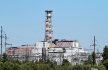
Created by the CHORNOBYL TOUR team, the map contains all the main tourist locations and reflects the state of Chornobyl tourism in general. The map is made in the original style and shows the most interesting objects of the Exclusion Zone and bordering areas: the ChNPP with a cooling pond in which the world-known cat fish dwell, the towns of Pripyat and Chernobyl with their most famous locations, the military town Chornobyl-2, antennas of the over-the-horizon radar system Duga-1, the memorial to Heroes-Liquidators, resettled villages, dumps of radioactive vehicles, the nature reserve, bears, elks, foxes, and wolves, - all of them are painted in details on the first tourist map of the Chornobyl zone.
The six main tourist locations are presented on the map separately - the Chornobyl Nuclear Power Plant, the town of Pripyat, the radar Duga-1, the city of Chornobyl, the catfish in the channel near the ChNPP, and the Memorial to the Liquidators "TO THOSE WHO SAVED WORLD". All these locations are included in the routes of one- and multi-day tours.
Despite its humorous style, the map is topographically correct and can be used in getting around.
The map is printed in Ukrainian and English and at the moment is being translated into other languages.
The price of the map:
unfolded map - 60 UAH (EUR, USD)
pocket version - 120 UAH (EUR, USD)
You are welcome to buy the map in the CHORNOBYL TOUR office, in the information&sales center located by Dytiatky checkpoint, and also through the website (please contact the managers).